Discover unparalleled precision and efficiency in geotechnical solutions with our cutting-edge equipment. Elevate your projects with advanced technology, ensuring accuracy and reliability for every geotechnical challenge you face
Showing 1–12 of 28 resultsSorted by latest
-
-

-
-
-
-
-
 KSh 5.00
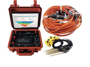
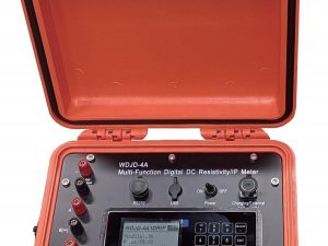
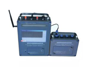
WDJD-4A Resistivity and IP Instrument
All Equipment, Geophysical Instruments, Geotech, Water SolutionsWDJD-4A Resistivity and IP InstrumentAdd to cart -
-
 KSh 413,000.00
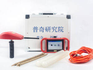
PQWT-GT500A Auto-analysis Geophysical Detector
All Equipment, Geotech, PQWT, Sellers, Water Detection Equipment, Water SolutionsModel: PQWT-GT500A Depth: 100m/150m/300m/500m Measuring time: 8-10min Measurement data unit electric field component of different frequencies of the earth electromagnetic field ΔVs (mV) Maximum Channels: 18 channels Display Screen: Industrial 10.1-inch HD touch screen. A/D conversion: 16-bits 1Msps Minimum resolution: 0.001mv Point selection: 1-18 points optional. Power consumption: about 9W Working environment temperature: -20°C ~ +50°C Controller: 32-bit high speed CPU Standby time: 8h Cable: 2.5m point pitch, 10m line pitch 54.7m in total length Electrode: Each comes standard with 22pcs Host Weight: 1.95kgAdd to cart -
 KSh 234,796.00The PQWT-TCM500 Long Range Automatic Mapping Underground Water Detector uses natural electric field technology to identify groundwater, aquifers, and geological structures. It automatically analyzes resistivity variations, mapping faults, fractures, and cavities with high precision, and delivers real-time subsurface profiling and clear visual data interpretation. Ideal for groundwater exploration.Add to cart
 -
 KSh 1,101,843.00
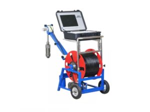
GYGD-IV Rotary Borehole Inspection Camera (500M)
All Equipment, Borehole Inspection Camera, Geotech, Water SolutionsGYGD-IV 360 Rotary Borehole Inspection Camera is a new model deep well camera with a 12-inch screen, 32G USB storage and keyboard input. This borehole camera can see both down view and lateral view at same time. It is integrated with the functions of borehole photographing, video recording and text input. It can be used to obtain borehole dynamic video and high-definition photos simultaneously, and it also has 8 times digital magnification function. It uses a low power embedded dual core processor. The camera system includes a monitor, an electrical winch, and a downhole camera probe. Length: 500MAdd to cart -
 KSh 594,230.00
PQWT-TC1200 Automatic Mapping Water Detector
All Equipment, Geotech, PQWT, Water Detection Equipment, Water SolutionsModel: PQWT-TC1200 Depth: 600 / 900 / 1500 Meters Frequency: Single, Triple, 30, 48, 62, 98 customized frequency Channel: 8 System: PQWT LCD: Industrial 7-inch HD touch screen Units of Measurement: △Vs(mV) Measurement Range: 0mV-2000mV Stand-by Time: 8-10 hours Power Supply: Controllable External PowerAdd to cart